
Below are answers to common questions. If you have any other questions, please contact us.
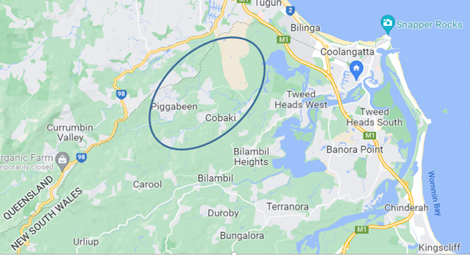
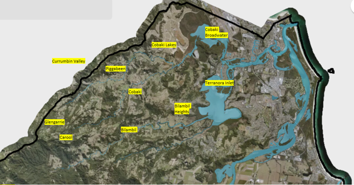
Piggabeen is the northern most valley in NSW and is directly to the south of its more famous Queensland neighbour, Currumbin Valley. Cobaki is directly to the south of Piggabeen, and both Piggabeen and Cobaki are accessed by a single access road through Cobaki Lakes.
Glengarrie and Carool are valleys to the west, and Bilambil is to the south.
Many families have lived in the Valley for generations, and they regard anyone who has lived here for less than 35 years as “new”! The times however are a changing……
Over the five year period from 2011-2016 and 2016-2021, thirty houses sold. In the 12 months period from July 2021 to June 2022, twelve houses sold, indicating a doubling in the rate of sales, or new people moving into the Valley.
According to the 2021 Census, 578 people, or 167 families, live in the valley.
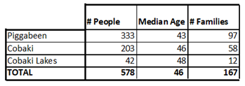
Whilst the number of people has roughly stayed the same over the past decade, the average age has increased from 40 to 46.
What access roads are there into the Valleys? Is there a road into the Valley from Currumbin Valley, Bilambil or Carool?
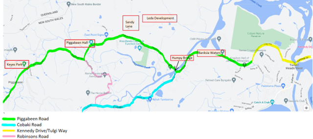
There is only one road into the Valleys and this is Piggabeen Road, accessed via Kennedy Drive.
Currumbin Valley also has a Piggabeen Road running along the border, and even though it appears on some maps that these two roads are connected, they are not. Some Piggabeen properties border onto Queensland, however the States of NSW and Qld have strict biosecurity laws and tightly control access across the border via a locked gate system.
Is there all weather access to the Valley?
There are many places along Piggabeen and Cobaki Roads that flood during periods of high rainfall. In addition, during high/king tides, Piggabeen Road floods at Banksia Waters.
The road at Banksia Waters typically floods first, and a live streamed flood camera is operated by Council. View images here before you head out.
The bridges at Eva Crescent and the intersection of Robinsons and Cobaki Road are regularly washed away in floods. Heed all flood water warnings when driving!
PHOTOS
How do I know when its high tide at Banksia Waters?
Look at the Cobaki Broadwater tides, and not the Tweed Heads tides.
https://tides.willyweather.com.au/nsw/far-north-coast/tweed-river–cobaki-broadwater.html
You will often hear reference to Banksia Waters (aka “over 55’s”, “the Barracks”, “old age home”) as this area is usually the first to have water over the road at high tide or during major rains.
The Humpy Bridge crosses Cobaki Creek, and is aptly named after its hump. The community notice board is at the bridge.
The Leda Development aka the Cobaki Lakes Development is a Council approved development to put 5,500 homes in Cobaki Lakes. The enormous pile of gravel will confirm its location. Part of this approval provides shops and infrastructure to the new community, as well as access to Tugun via Sandy Lane. The development has been in the planning stage for well over a decade, and a dead giveaway is all the trees growing in the gravel pile! Evidently Bob Leda, the owner, has a similar development in Kings Forest, which he is developing first.
Piggabeen Hall is a heritage listed hall built in 1910 and owned by Council. It is managed by the Piggabeen and Cobaki Community Association and is used for community events, as well as being rented out for private hire. The Hall is across the road from the old school, which is home to the RFS fire truck
Keyes Park is along Piggabeen Road and used for outdoor community events
When are waste collection days?
Waste collection is early on Thursday mornings.
Tweed Council offers a garbage collection (red bin) every week and a recycling collection (yellow bin) every fortnight. A vegetation (green bin) collection is not offered.
Check your next waste collection here
https://www.tweed.nsw.gov.au/property-rates/waste-recycling/bin-services-collection/bin-collection-days
Each household is also able to book two kerbside collections each financial year. If you book close to the end of June, the collection will come out of your allocation on the date you book and not the date of collection.
Ring Council on 02 6670 2400 to arrange your collection.
What is the difference between Tank and Town water?
The vast majority of houses in the Valleys are on tank water. Tank is different from towns- it runs out!
It can only be pumped on demand when there is water in the tank and power to operate the pump. This is something to plan for when formulating your bushfire plan.
Who is the power wholesaler to the Valley?
Essential Energy is the Valleys’ power wholesaler. Report outages or check for them here
https://www.essentialenergy.com.au/outages-and-faults/power-outages/
I have solar panels. Does that mean I will be unaffected during power outages?
Well that depends whether you have an off grid system or not. If you are connected to the grid you will lose power. If like most people you have solar panels with no batteries and obtain power over the grid, you will lose power when there is an outage. For people on tank water, this means you will lose water too as your water pump will not have the power it needs to operate.
It’s a good idea to locate the valves on your water tank so you can access water in the event of a power failure.
I have a burn pile. How do I get a fire permit?
In 2022, the Bush Fire Danger Period runs from 1st September until 31st March. During this time Fire Permits will be required and you will be required to give your neighbours 24 hours notice before lighting up.
An inspection may be required before the permit will be granted, so allow extra time to obtain it.
Full details of how to obtain a permit are given here
https://www.rfs.nsw.gov.au/fire-information/fire-permits
I have a bush block which is overrun with weeds. What help is available to restore it?
Tweed Council offers a “Land for Wildlife” program for those wishing to conserve their bush blocks and maintain their habitat to encourage wildlife.
On application to participate, Council sends a representative to assess the block, and if your block is eligible, Council offers grants to help pay for regenerating your bushland.
Michael Cork from Council leads the program. He is on 02 6670 2592 or MCorke@tweed.nsw.gov.au
I have feral animals on my property. What should I do?
The Feral Scan website requests pest animal activity is recorded to protect farms, biodiversity and communities
Where can I get a trap to catch feral animals? Should I bait instead?
Tweed Council has a limited number of traps available to loan out to residents to trap feral animals. Please contact
Mark Schirmer
Biosecurity Officer
Local Land Services
M 0409 780 695
If you wanted to bait instead of trap, please talk to Mark prior as there are strict requirements and controls including the requirement of:
- A current chemical accreditation
https://www.tocal.nsw.edu.au/courses/short-courses/biosecurity/vertebrate-pesticide
- Notifying of all properties within 1km at least three (3) days prior to the baiting commencement date on the notification letter. Baiting can commence up until 21 days after notification.
I have a snake in my house. What should I do?
Sarah Mailey, our local Piggabeen snake catcher, has provided this advice
https://www.facebook.com/photo?fbid=981891702943969&set=pcb.709403520584829
You may wish to keep a snake bandage and phone on you at all times when you are out on your property in case you get bitten. A snake bandage is unique in that it has a unique indicator to show the correct tension.
Link to https://www.chemistwarehouse.com.au/buy/90006/snake-bite-bandage-10cm-x-10-5m
How can I prepare for adverse events?
During high rainfall events, the Valleys can be flooded in for days. Stock your pantry when big rain events are expected!
The Association is in the process of launching the “Community-Led Resilience Team” (CRT) program in conjunction with the Red Cross. This program helps all residents forward plan for natural disasters such as flood, fire, medical emergency etc, and provides satellite phones for emergency assistance in the event communication lines go down.
The Association is calling for volunteers to be Street Coordinators. Please contact us if you would like to be involved and represent your street.
Its rained a lot. How do I know how much rain has fallen?
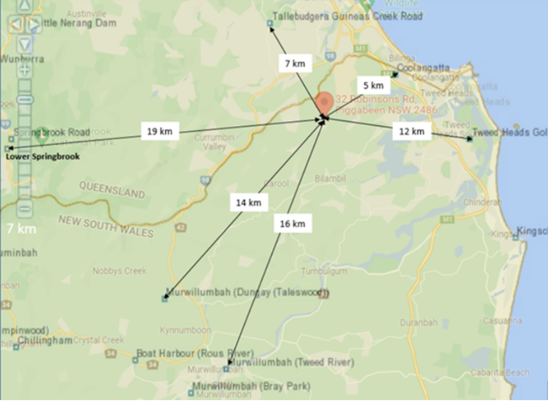
No BOM weather stations are located in the Valleys, and the surrounding BOM stations are at least 5 km away.
There is however a website called Weather Underground, which collects data from private weather stations and makes that data visible to the public.
There are two private weather stations in the valley- one in Green Valley Way in Piggabeen,
https://www.wunderground.com/dashboard/pws/IPIGGA1
and one in Quambie Road in Cobaki
https://www.wunderground.com/dashboard/pws/I90581274
Data is uploaded every 5 minutes, and if you scroll down the page, you will find the option to look at historical data.